VII.2.2. Physical properties of rivers
The summer temperature of the water of Hungary’s rivers is ideal for tours. The temperature of the water itself is not significant from the point of view of boating, but it may influence accompanying recreational activities including swimming, or playing in water Water temperature changes depending on insolation and heat emission, but, due to water mixture it is nearly the same at each point of the river’s cross section. Daily changes in temperature rarely exceed 1 oC. An interesting fact in connection with winter tepreature is, that freezing can take place in the depth as well. Since the specific weight of ice is less that that of the water, the ice slush located at the bottom of the river comes up to the surface and forms an ice-floe. Clear-water and fast rivers take longer to freeze. (Moholi 1988).
Rate of flow and water level represent very significant data for travellers on water. Rate of flow represents how much water flows through the cross section of the river during a given period of time (1 s). The rate of flow of the Danube is for example in summer 1000-1500 m3/s. The rate of flow depends on the size of the watershed area, the amount of precipitation, the intensity of evaporation, and also on how much water the rocks of the riverbottom can absorb. An increase in the rate of flow leads to an increase in water level (flooding), while its decrease means a decrease in water level, that is recession. The regularity of these processes depends on precipitation, the annual distribution of precipitation and the periods when snow and glaciers melt. Rivers in Hungary – due to our wet continental climate – are characterized by floods in springs and in early summers, and minimum water levels in autumns and in early winters.
Water level is identified in relation to point 0 of the fluviometer. (e.g. in Szeged point 0 is at 73,67 m above the level of the Baltic Sea). Fluviometers can be found in certain parts of riverbeds, or, on embankments, bridges or floodgates. Water level can be high, of medium height, low and flooding, if the water runs out of the riverbed.
Monitoring water levels is very important from the point of view of boating trips, The National Water Level Observation Service publishes data on a daily basis on water levels of Hungary’s rivers.
Water levels are reported in relation to certain settlements. It is given in centimeters and means the height of water compared to the 0 point of the local fluviometer. The % value relates it to the highest water level value ever measured (100%). The water level report informs us on floods and recessions.
Floods can be real obstacles in water tourism. Streams and small rivers (e.g. Sajó, Hernád, Rába) flood very quickly, but water level goes down very quickly, too. Rivers of large flat areas flood very slowly. When rivers are flooding the process is faster in the beginning while the receding period is slower. (Figure 2.).
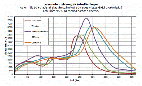
Source:http://www.hidrologia.hu/vandorgyules/31/dolgozatok/046_lucza_zoltan.html
Due to the possible danger of floods very careful planning is needed when organizing boating tours. Flooding waters mean that water flows quickly, currents change, more alluvial deposit is carried and thus tourists are to face underwater obstacles unexpectedly and they also have to struggle with poorer water quality. Since the majority of riverside areas get flooded, many of the former campsites and peaceful harbours get underwater now. Higher water levels might reduce the attraction of the river, which may flood riverside beaches, restaurants and other tourist faclilities.
It is due to the gravitation that rivers move along the banks. Their speed depends on their fall and rate of actual water flow. Fall means that in a section of 1km how many metres the level of the river bread falls. (E.g. The fall of the Tisza River in Szeged is 0,03 ‰,, which means 3 centimetres. ). The speed of the water current is the lowest in the bottom and by the two banks and it is the highest in the current. Water speed is higher on the concave side of bends; in the inner side it might even stop or might flow backwards.(limány). The direction of the drifting objects on the surface shows where the current is. Flooding water flows rapidly, receding water flows slowly. These are points to consider when planning a tour. (Bánhidi 2013).
Fast rivers are not suitable for tours; it is difficult to anchor boats near their banks, and their water level might also change very quickly. These rivers are more popular with lovers of extreme sports. Slow moving rivers do not pose a risk for people, they are more likely to become target areas for water tourism. On the other hand, they are not very popular either, because sometimes people like to move with their boats without having to row, they want to move down with the ’stream’ and they like to become passive tourists every now and then. (Donka 2012, pp. 9-10)”.
Waves come into being under the influence of wind, some obstacle in the water, and as a result of moving vehicles. The lateral forces of waves may turn up smaller boats unless they are turned to face the waves. (Bánhidi 2013).