VII.2.1. Size and geometrical features of rivers
Rivers are fed by springs, precipitation, and melted snow and ice. The hierarchical system of rivers, which eventually unite into one big river is called river system or river network. There are streams and tributaries of different size that make up a big river. The denseness of a river system depends on the climate, the flora of the given area, as well as the stucture of its surface and the quality of its rocks. Watershed is an area, the waters of which are drained by a river. This area is surrounded by divides, which are usually topographically high places.
For further details see.http://tudasbazis.sulinet.hu/hu/termeszettudomanyok/foldrajz/termeszetfoldrajz/vizfolyasok-jellemzoi/a-vizgyujto-terulet-es-a-vizvalaszto
The flood zone of a river is part of the river’s valley, which may be flooded. If the river has been regulated, then it is an area, which used to be flooded. The river dams divide this area into two parts: the flood plain and the flood-free zone. (Figure 1).
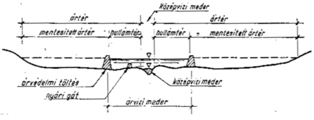
Figure 1. Cross section of a river valley after flood barrier construction
Source: www.agr.unideb.hu/ktvbsc/dl2.php?dl=10/9_eloadas.ppt
The ’site’ of tours on water is varied. The width, depth and speed of the rivers are varied, too, and these features may also change depending on the season and weather conditions. The riverbed is actually a long uneven ditch, which was brought about by flowing water. Its deepest part is called riverbottom, its side is the bank. The intersection between the bank and the side is the edge. If we face the direction of the flow the right bank is on our right and the left bank is on our left.
The geometry of the riverbed does not have a major influence on water tourism, still it can be stated that smaller or medium-size rivers are ideal for tours. Wide rivers with large water surface, including the section of the Danube on the Great Plain offers fewer experiences visually. (Narrower rivers represent a more beautiful sight for people). The depth of the water is significant only when it is too shallow and represents a physical obstacle. The Hernád River can be taken as an example during the dry summer months.
For further details see.
http://old.foldrajz.ttk.pte.hu/tfk/pdf/2012/2012_1_2_1.pdf
The shape of the cross section of the river bed is influenced by the mechanical energy of the water current and the hardness of rocks on the surface. In straight sections of the river the riverbed is symmetrical, while in bends it is asymmetrical. Due to the centrifugal force in the bends the water is pushed toward the concave side and this is why the current, the speediest part of the moving water deepens the riverbed. The bank is steeper at places like this. In winding rivers this line is rarely identical with the line dividing the river into two.
The longitudinal section of the river shows changes of the depth. The depth of rivers, compared to their length is not significant. Shorter rivers are usually 2-3 m deep, while the depth of longer rivers can be about 10 m. (Zseni, Bulla 2002). A diagram can also be drawn showing the fall of the river from the origin to its mouth. But a similar diagram can be drawn in relation to the section of the river, where the boating trip takes place.